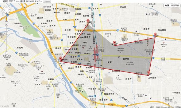
[GMaps API v3] geometryライブラリを使って距離や面積を測る。
Google Maps APIのgeometryライブラリを使用すると、地図上の地点間の距離や面積を簡単に取得することができます。
サンプルコード
geometryライブラリを使用する際はGoogle Maps APIの読み込み時に「libraries=geometry」を付けて読み込みます。
|
1 |
<script src="http://maps.googleapis.com/maps/api/js?v=3.6&sensor=false&libraries=geometry"></script> |
|
1 2 3 4 5 6 7 8 9 10 11 12 13 14 15 16 17 18 19 20 21 22 23 24 25 26 27 28 29 30 31 32 33 34 35 36 37 38 39 40 41 42 43 44 45 46 47 48 49 50 51 52 53 54 55 56 57 58 59 60 61 62 63 64 65 66 67 68 69 70 71 72 73 74 75 76 77 78 79 80 81 82 83 84 85 86 87 88 89 90 91 92 93 94 95 96 97 98 99 100 101 102 103 104 105 106 107 108 109 110 111 112 113 114 115 116 117 118 119 120 121 122 123 124 125 126 127 128 129 130 131 132 133 134 135 136 137 138 139 140 141 142 |
google.maps.event.addDomListener(window, "load", initialize); function initialize() { google.maps.visualRefresh=true; //Google map新スタイルを使用 //Mapオブジェクトを作成 var mapDiv = document.getElementById("map_canvas"); var mapObj = new google.maps.Map(mapDiv, { center : new google.maps.LatLng(36.322356, 139.013057), zoom : 15, mapTypeId : google.maps.MapTypeId.ROADMAP, draggableCursor: "crosshair" }); // マーカー・ライン・ポリゴン情報を保管するオブジェクト var measure = { mvcLine: new google.maps.MVCArray(), mvcPolygon: new google.maps.MVCArray(), mvcMarkers: new google.maps.MVCArray(), line: null, polygon: null }; //地図にクリックイベントを設定 google.maps.event.addListener(mapObj, "click", function(evt) { //地図クリック時にマーカー、ライン、ポリゴンを追加 measureAdd(evt.latLng); }); //マーカー、ライン、ポリゴンを追加する function measureAdd(latLng) { //新規マーカー作成 var marker = new google.maps.Marker({ map: mapObj, position: latLng, draggable: true, raiseOnDrag: false, title: "ドラッグで移動できます" }); //ライン情報を追加 measure.mvcLine.push(latLng); //ポリゴン情報を追加 measure.mvcPolygon.push(latLng); //マーカー情報を追加 measure.mvcMarkers.push(marker); //ラインの頂点の数を更新 var latLngIndex = measure.mvcLine.getLength() - 1; //マーカードラッグイベント設定、ドラッグされたらライン情報・ポリゴン情報を更新する google.maps.event.addListener(marker, "drag", function(evt) { measure.mvcLine.setAt(latLngIndex, evt.latLng); measure.mvcPolygon.setAt(latLngIndex, evt.latLng); }); //マーカードラッグ終了後イベント設定、マーカーのドラッグ・移動が終わったら距離・面積の計算を行う google.maps.event.addListener(marker, "dragend", function() { if (measure.mvcLine.getLength() > 1) { measureCalc(); } }); // ラインの頂点が1以上ある場合 if (measure.mvcLine.getLength() > 1) { // ラインが作成されていなければ作成する if (!measure.line) { measure.line = new google.maps.Polyline({ map: mapObj, clickable: false, strokeColor: "#FF0000", strokeOpacity: 1, strokeWeight: 3, path:measure. mvcLine }); } // ラインの頂点が2つ以上ある場合 if (measure.mvcPolygon.getLength() > 2) { // ポリゴンが作成されていなければ作成する if (!measure.polygon) { measure.polygon = new google.maps.Polygon({ clickable: false, map: mapObj, fillOpacity: 0.25, strokeOpacity: 0, paths: measure.mvcPolygon }); } } } // ラインの頂点の数が1以上の時は距離と面積を計算する if (measure.mvcLine.getLength() > 1) { measureCalc(); } } //距離・面積の計算 function measureCalc() { // geometryライブラリ使用して距離を計算する var length = google.maps.geometry.spherical.computeLength(measure.line.getPath()); jQuery("#distance").text(length.toFixed(1)) // ラインの頂点が2つ以上ある場合は面積を計算する if (measure.mvcPolygon.getLength() > 2) { var area = google.maps.geometry.spherical.computeArea(measure.polygon.getPath()); jQuery("#area").text(area.toFixed(1)); } } //マーカー・ライン・ポリゴンのリセット function measureReset() { // ポリゴンが作成されているならばnullをセット if (measure.polygon) { measure.polygon.setMap(null); measure.polygon = null; } // ラインが作成されているならばnullをセット if (measure.line) { measure.line.setMap(null); measure.line = null } //MVCArraysのライン・ポリゴン情報をクリア measure.mvcLine.clear(); measure.mvcPolygon.clear(); // マーカーを削除する measure.mvcMarkers.forEach(function(elem, index) { elem.setMap(null); }); measure.mvcMarkers.clear(); jQuery("#distance,#area").text(0); } //リセットボタンにイベントを設置 $('#reset').click(measureReset); } |