【D3.js】文字で日本地図書いてみた。
またもや小ネタです。
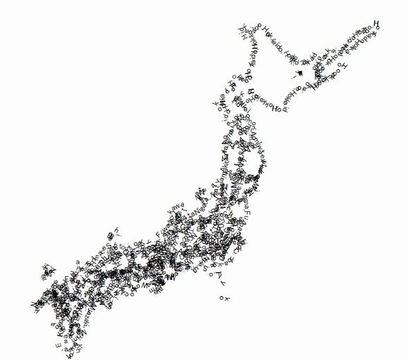
文字を使って日本地図を描いてみました。
北海道は「Hokkaido」でと、一応各県名でエリアを描画しているんですが……まったく分かりませんね。
綺麗に表示する方法が分かったら、また挑戦してみたいとおもいます。
サンプル
ポイントは地形のpathをdef要素の中に描き、県名をidとしてtextpathにリンクさせているところです。
これだけで、pathに沿ってテキストが表示されます。
|
1 2 3 4 5 6 7 8 9 10 11 12 13 14 15 16 17 18 19 20 21 22 23 24 25 26 27 28 29 30 31 32 33 34 35 36 37 38 39 40 41 42 43 44 45 46 47 48 |
d3.json("ken.topojson", function(json) { draw(json); }); function draw(json){ var geodata = json.objects.ken; var projection = d3.geo .mercator() //投影法の指定 .scale(1900) //スケール(ズーム)の指定 .translate([500,450]) //表示位置調整 .center([139.0032936, 36.3219088]); //中心の座標を指定 var path = d3.geo.path().projection(projection); //パスジェネレーター var svg = d3.select("svg"); var def = svg.append("def"); //svgにおける関数のような要素。再利用が可能 //地図描画(pathをdef内に作成) var map = def.append("g") .attr("class", "land") .selectAll("path") .data(topojson.feature(json, geodata).features) .enter().append("path") .attr("d", path) .attr("stroke", "red") .attr("id", function(d){ //pathのidとして県名を指定 return d.properties.ObjName_1; }) //テキスト要素追加 var text = svg.selectAll('text') .data(topojson.feature(json, geodata).features) .enter() .append("text") .append("textPath") .attr("xlink:href", function(d){ //defの中に書きこまれたpathをidで呼び出しテキストに適用する return "#"+d.properties.ObjName_1; }) .text(function(d){ var a = d3.range(0,50) .map(function(){ return d.properties.ObjName_1 }); return a }) } |