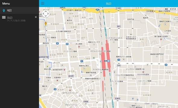
スマートフォン用UIフレームワーク「lungo.js」で地図アプリを作ってみる
とある事情により、スマホ向けに地図を使ったWebApp的なものを作る必要があって、モバイル向けフレームワークをいろいろ試しています。
個人的には「lungo.js」というフレームワークが手持ちのiPhone4sで見てもキビキビ動いて気に入ったのですが、IEにはまったく対応していないらしいので今回は見送り。(公式のKitchenSinkもIE10で動かなかったので、IEは完全スルーという方針らしいです)
かなり性能の良いフレームワークだと思うのですが、日本語ドキュメントはおろか英語のドキュメントすら公式以外にはほとんど見当たらないというニッチさ。
興味がある方は使ってみてください。
サンプル
|
1 2 3 4 5 6 7 8 9 10 11 12 13 14 15 16 17 18 19 20 21 22 23 24 25 26 27 28 29 30 31 32 33 34 35 36 37 38 39 40 41 42 43 44 45 46 47 48 49 50 51 52 53 54 55 56 57 58 59 60 61 62 63 64 65 66 67 68 69 70 71 72 73 74 75 76 77 78 79 80 81 82 83 84 85 86 87 88 89 90 91 92 93 94 95 96 97 98 99 100 101 102 103 104 105 106 107 108 109 110 111 112 113 114 115 116 117 118 119 120 121 122 123 124 125 126 127 128 129 130 131 132 133 134 135 136 137 138 139 140 141 142 143 144 145 146 147 148 149 150 |
<!doctype html> <html> <head> <meta charset="utf-8"> <title>lungo gmap</title> <meta name="description" content=""> <meta name="HandheldFriendly" content="True"> <meta name="viewport" content="initial-scale=1.0, maximum-scale=1.0, user-scalable=no" /> <meta name="apple-mobile-web-app-capable" content="yes"> <meta name="apple-mobile-web-app-status-bar-style" content="black"> <meta name="mobile-web-app-capable" content="yes"> <meta name="format-detection" content="telephone=no"> <meta http-equiv="cleartype" content="on"> <!-- Main Stylesheet --> <link rel="stylesheet" href="../css/lungo.css"> <link rel="stylesheet" href="../css/lungo.theme.css"> <link rel="stylesheet" href="../css/lungo.icon.css"> <style> html, body{ margin: 0px; padding: 0px; } html, body, #map { width: 100%; height: 100%; } </style> </head> <body> <!------------------------------------------------------------------------------------------------------- サイドメニュー ----------------------------------------------------------------------------------------------------------> <aside id="features" > <header> <h1 class="title text big">Menu</h1> </header> <article id="sss" class="list active"> <ul> <li class="active" data-view-article="map-art" data-title="地図" data-icon="map-marker"> <a href="#"> <strong>地図</strong> </a> </li> <li data-view-article="route-atr" data-title="施設" data-icon="align-justify"> <div class="tag count on-right">4</div> <strong class="text big">施設</strong> <small>タップした地点に移動</small> </li> </ul> </article> </aside> <!------------------------------------------------------------------------------------------------------- メインコンテンツ ----------------------------------------------------------------------------------------------------------> <section id="layout" data-transition="" data-aside="features"> <!-- ヘッダー --> <header data-tistle="Layout"> <nav class="on-left"> <a href="#" data-view-aside="features" data-icon="menu"></a> </nav> <h1 class="title centered"> タイトル </h1> </header> <!-- 地図ー --> <article id="map-art" class="active"> <div id="map"></div> </article> <!-- 施設一覧 --> <article id="route-atr" class="list scroll "> <ul> <li class="anchor contrast">高崎</li> <li> <a href="#" data-view-article="map-art" data-action="point_selected" data-latlng="36.322356,139.013057"> <strong>高崎駅</strong> </a> </li> <li> <a href="#" data-view-article="map-art" data-action="point_selected" data-latlng="36.3219477,139.00335240000004"> <strong>高崎市役所</strong> </a> </li> <li class="anchor contrast">大宮</li> <li> <a href="#" data-view-article="map-art" data-action="point_selected" data-latlng="35.906295,139.62399900000003"> <strong>大宮駅</strong> </a> </li> <li> <a href="#" data-view-article="map-art" data-action="point_selected" data-latlng="35.923507,139.63239"> <strong>大宮公園</strong> </a> </li> </ul> </article> <!-- <footer> <nav> <a href="#" data-view-article="map-art" data-icon="screenshot" class="active" ></a> </nav> </footer> --> </section> <script src="../quo.js"></script> <script src="../lungo.js"></script> <script type="text/javascript" src="http://maps.googleapis.com/maps/api/js?sensor=false"></script> <script> Lungo.init({ name: 'Flexbox', version: '2.2', history: false }); Lungo.ready(function() { //画面表示時に再度メニューを開く Lungo.Aside.show("features"); //Google Map 初期化 var map = new google.maps.Map(document.getElementById('map'), { zoom: 16, mapTypeId: google.maps.MapTypeId.ROADMAP, center: { lat: 35.906961392699998, lng: 139.622833797 }, }); $$("[data-action=point_selected]").tap(function(event) { var latlng = this.dataset.latlng.split(","); map.panTo(new google.maps.LatLng(latlng[0], latlng[1])); }); }); </script> </body> </html> |