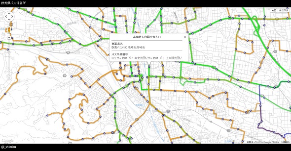
複数のFusion Tablesを一つの地図上に重ねて表示する。
残念ながら、Fusion Tablesは廃止されることになりました。
Notice: Google Fusion Tables Turndown – Fusion Tables Help
下記は群馬県のバスルートデータとバス停留所データのFusion Tablesを重ねて表示した例。
以前も紹介したことがあるFusion Tables。手軽に地理情報の視覚化が行えて非常に便利なのですが、Googleドライブの中では基本一つの地図に1種類のデータしか表示できません。
Google Maps APIコードエクスポート機能を使うと、複数のFusion Tablesを組み合わせて使うことができます。
サンプル
Google Maps APIコード出力
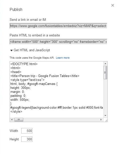
「Tools」メニューから「Publish」を選択し「Get HTML and JavaScript」をクリックするとGoogle Maps APIコードが取得できます。

出力されるコードにはGoogle Mapsの初期化などが含まれますが、Fusion Tablesを表示しているのは以下の部分となります。
|
1 2 3 4 5 6 7 8 9 10 11 12 13 |
layer = new google.maps.FusionTablesLayer({ map: map, heatmap: { enabled: false }, query: { select: "col6", from: "1jKSH39amF5BDFE0YZBJn0KZZPeX8oOMKpuwu0X1F", where: "" }, options: { styleId: 2, templateId: 2 } }); |
google.maps.FusionTablesLayerで指定したFusion Tablesを生成しGoogle Maps上に表示しているわけですが、この部分をコピペして一つのGoogle Mapsに追加すれば複数のFusion Tablesを1つの地図上に重ねて表示できます。
(一部webixを使ってます。divエレメントを生成しているだけです。)
|
1 2 3 4 5 6 7 8 9 10 11 12 13 14 15 16 17 18 19 20 21 22 23 24 25 26 27 28 29 30 31 32 33 34 35 36 37 38 39 40 41 42 43 44 45 46 47 48 49 50 51 52 53 54 55 56 57 58 59 60 61 62 63 64 65 66 67 68 69 70 71 72 73 74 75 76 77 78 79 80 |
webix.ui({ rows:[ {css: "header",template:"群馬県バス停留所", height:35 }, {css:"map_view", template:' <div id="googft-mapCanvas"></div>'}, {css:"footer", template:"@_shimizu", height:35 }, ] }).show(); function initialize() { google.maps.visualRefresh = true; var isMobile = (navigator.userAgent.toLowerCase().indexOf('android') > -1) || (navigator.userAgent.match(/(iPod|iPhone|iPad|BlackBerry|Windows Phone|iemobile)/)); if (isMobile) { var viewport = document.querySelector("meta[name=viewport]"); viewport.setAttribute('content', 'initial-scale=1.0, user-scalable=no'); } var mapDiv = document.getElementById('googft-mapCanvas'); var style_array_from_above_here = [{"featureType":"water","elementType":"all","stylers":[{"hue":"#e9ebed"},{"saturation":-78},{"lightness":67},{"visibility":"simplified"}]},{"featureType":"landscape","elementType":"all","stylers":[{"hue":"#ffffff"},{"saturation":-100},{"lightness":100},{"visibility":"simplified"}]},{"featureType":"road","elementType":"geometry","stylers":[{"hue":"#bbc0c4"},{"saturation":-93},{"lightness":31},{"visibility":"simplified"}]},{"featureType":"poi","elementType":"all","stylers":[{"hue":"#ffffff"},{"saturation":-100},{"lightness":100},{"visibility":"off"}]},{"featureType":"road.local","elementType":"geometry","stylers":[{"hue":"#e9ebed"},{"saturation":-90},{"lightness":-8},{"visibility":"simplified"}]},{"featureType":"transit","elementType":"all","stylers":[{"hue":"#e9ebed"},{"saturation":10},{"lightness":69},{"visibility":"on"}]},{"featureType":"administrative.locality","elementType":"all","stylers":[{"hue":"#2c2e33"},{"saturation":7},{"lightness":19},{"visibility":"on"}]},{"featureType":"road","elementType":"labels","stylers":[{"hue":"#bbc0c4"},{"saturation":-93},{"lightness":31},{"visibility":"on"}]},{"featureType":"road.arterial","elementType":"labels","stylers":[{"hue":"#bbc0c4"},{"saturation":-93},{"lightness":-2},{"visibility":"simplified"}]}]; var map = new google.maps.Map(mapDiv, { center: new google.maps.LatLng(36.322356, 139.013057), zoom: 14, mapTypeId: google.maps.MapTypeId.ROADMAP, styles: style_array_from_above_here }); map.controls[google.maps.ControlPosition.RIGHT_BOTTOM].push(document.getElementById('googft-legend-open')); map.controls[google.maps.ControlPosition.RIGHT_BOTTOM].push(document.getElementById('googft-legend')); //バスルートデータのFusion Tablesを表示 var buss_route = new google.maps.FusionTablesLayer({ map: map, heatmap: { enabled: false }, query: { select: "col8", from: "1x3vlOo5wVXoMjsbS3sRT75LdSZ4KMeo5JGMNKGeQ", where: "" }, options: { styleId: 2, templateId: 2 } }); //バス停留所データのFusion Tablesを表示 var buss_stop = new google.maps.FusionTablesLayer({ map: map, heatmap: { enabled: false }, query: { select: "col6", from: "1jKSH39amF5BDFE0YZBJn0KZZPeX8oOMKpuwu0X1F", where: "" }, options: { styleId: 2, templateId: 2 } }); if (isMobile) { var legend = document.getElementById('googft-legend'); var legendOpenButton = document.getElementById('googft-legend-open'); var legendCloseButton = document.getElementById('googft-legend-close'); legend.style.display = 'none'; legendOpenButton.style.display = 'block'; legendCloseButton.style.display = 'block'; legendOpenButton.onclick = function() { legend.style.display = 'block'; legendOpenButton.style.display = 'none'; } legendCloseButton.onclick = function() { legend.style.display = 'none'; legendOpenButton.style.display = 'block'; } } } google.maps.event.addDomListener(window, 'load', initialize); |
FusionTablesLayerのsetQueryメソッドを使って表示するデータの絞り込みなども行えるのですが、それについてはまた後日書きます。